S.I. No. 492/2022 - Planning And Development (Solar Safeguarding Zone) Regulations 2022
Notice of the making of this Statutory Instrument was published in | ||
“Iris Oifigiúil” of 7th October, 2022. | ||
I, DARRAGH O’BRIEN, Minister for Housing, Local Government and Heritage, in exercise of the powers conferred on me by subsection (2) of section 4 and section 262 of the Planning and Development Act 2000 (No. 30 of 2000) (as adapted by the Housing, Planning and Local Government (Alteration of Name of Department and Title of Minister) Order 2020 (S.I. No. 408/2020)), hereby make the following regulations: | ||
Citation | ||
1. (1) These Regulations may be cited as the Planning and Development (Solar Safeguarding Zone) Regulations 2022. | ||
(2) These Regulations shall be included in the collective citation the Planning and Development Regulations 2001 to 2022. | ||
Interpretation | ||
2. In these Regulations “Solar Safeguarding Zone” means an area classified under Article 3 as a Solar Safeguarding Zone; | ||
Solar Safeguarding Zone | ||
3. An area identified by reference to a map contained in Schedule 1 and further referred to in Schedule 2 is classified as a Solar Safeguarding Zone. | ||
Schedule 1 | ||
Article 3 | ||
Solar Safeguarding Zone Maps | ||
| ||
| ||
| ||
| ||
| ||
| ||
| ||
| ||
| ||
| ||
| ||
| ||
| ||
| ||
| ||
| ||
| ||
| ||
| ||
| ||
| ||
| ||
| ||
| ||
| ||
| ||
| ||
| ||
| ||
| ||
| ||
| ||
| ||
| ||
| ||
| ||
| ||
| ||
| ||
| ||
| ||
| ||
| ||
Schedule 2 | ||
Article 3 | ||
Description of areas classified as a Solar Safeguarding Zone | ||
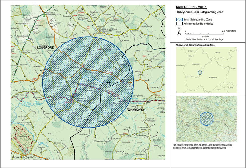
Map 1: Abbeyshrule Solar Safeguarding Zone | ||
The area known as Abbeyshrule Solar Safeguarding Zone is situated: | ||
(1) in the county of Longford being the area enclosed on map 1 (contained in Schedule 1) within the inner margin of the blue line and hatched in blue and is situated in whole or in part in the townland[s] of: Abbeyshrule, Agharra, Ardanragh, Ballymacshane, Ballynamanagh, Castlewilder, Cloghan, Cloonbrin, Clynan, Colehill, Deerpark, Drumanure, Furze, Glebe, Killeenboy, Killinbore, Kilnacarrow, Kinard, Knockagh, Legan, Lisaquill, Lisnacreevy, Lissawarriff, Ratharney, Rathsallagh, Sheeroe, Streamstown, Taghshinny, Tennalick, and Vicarstown, | ||
and | ||
(2) in the county of Westmeath being the area enclosed on map 1 (contained in Schedule 1) within the inner margin of the blue line and hatched in blue and is situated in whole or in part in the townland[s] of: Ballymaglavy, Ballynacarrow, Castlegaddery, Emper, Kilphierish, Rath (Malone), Rathcaled, and Williamstown. | ||
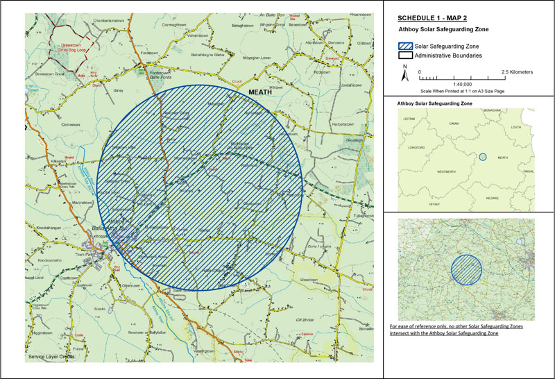
Map 2: Athboy Solar Safeguarding Zone | ||
The area known as Athboy Solar Safeguarding Zone is situated in the county of Meath being the area enclosed on map 2 (contained in Schedule 1) within the inner margin of the blue line and hatched in blue and is situated in whole or in part in the townland[s] of: Ballyboy, Balruntagh, Clonymore, Curleyland and Mill Land, Derlangan, Drissoge, Eightyeight Acres, Fordrath, Fordstown, Fostersfields, Gillstown Great, Gillstown Little, Girley, Hospital Land, Jamestown, Martinstown, Mitchelstown, Mooneystown, Moyagher, Mullaghstones, Newtown Girley, Rathcarran, Rathconny, Rathmore, Town Parks, and Wardstown. | ||
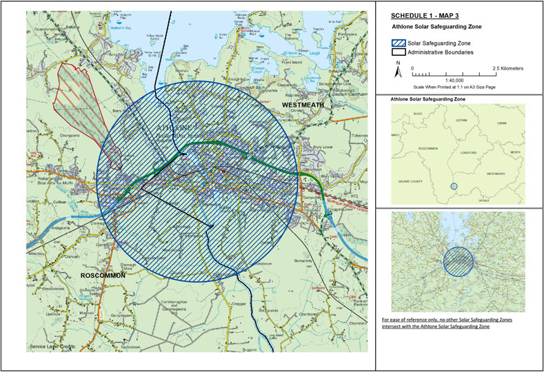
Map 3: Athlone Solar Safeguarding Zone | ||
The area known as Athlone Solar Safeguarding Zone is situated: | ||
(1) in the county of Roscommon being the area enclosed on map 3 (contained in Schedule 1) within the inner margin of the blue line and hatched in blue and is situated in whole or in part in the townland[s] of: Barry Beg, Bellaugh, Bogganfin, Bunnaribba, Carrickynaghtan, Carrickynaghtan and Garrynagawna Bog, Crannagh, Crannagh Beg, Crannagh More, Doovoge, Kilnamanagh, and Monksland, | ||
and | ||
(2) in the county of Westmeath being the area enclosed on map 3 (contained in Schedule 1) within the inner margin of the blue line and hatched in blue and is situated in whole or in part in the townland[s] of: Aghacocara, Ankers Bower, Ardnaglug, Athlone, Athlone and Bigmeadow, Bellaugh, Bogganfin, Bunnavally, Canal and Banks, Cannonsfield, Carrickobreen, Cartrontroy, Cloghanboy (Cooke), Cloghanboy (Homan), Cloghanboy (Strain), Cloghanboy West, Clonbrusk, Collegeland, Coosan, Cornamaddy, Cornamagh, Creaghduff, Creaghduff South, Curragh, Curragh (Mechum), Derries, Doovoge, Garrankesh, Garrycastle, Garrynafela, Golden Island, Golden Island (Kilmaine), Golden Island (St. George), Hillquarter, Kilmacuagh (Castlemaine), Kilmacuagh (Cooke), Kilmacuagh (Mechum), Kilnafaddoge, Lissywollen, Loughanaskin, Loughandonning, Magheranerla, Meehan, Monksland, Ranelagh, Retreat, Retreat, Tullin, and Warrens Fields. | ||
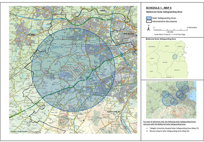
Map 4: Baldonnel Solar Safeguarding Zone | ||
The area known as Baldonnel Solar Safeguarding Zone is situated: | ||
(1) in the county of Kildare being the area enclosed on map 4 (contained in Schedule 1) within the inner margin of the blue line and hatched in blue and is situated in whole or in part in the townland[s] of: Ballymadeer, Balscott, Dangan, Elmhall, Loughlinstown, Lyons, Stacumny, Stacumny Cottage, and Straleek, | ||
and | ||
(2) in the county of South Dublin being the area enclosed on map 4 (contained in Schedule 1) within the inner margin of the blue line and hatched in blue and is situated in whole or in part in the townland[s] of: Adamstown, Aderrig, Athgoe, Athgoe North, Athgoe South, Aungierstown and Ballybane, Backstown, Baldonnell Little, Baldonnell Lower, Baldonnell Upper, Balgaddy, Ballybane, Ballymakaily, Ballymanaggin, Ballymount Great, Ballynakelly, Ballyowen, Bawnoges, Bedlesshill, Belgard, Blundelstown, Boherboy, Brideswell Commons, Brownsbarn, Brownstown, Buckandhounds, Bushelloaf, Bustyhill, Cappagh, Carrigeen, Cheeverstown, Clonburris Great, Clonburris Little, Clondalkin, Clutterland, Coldwater Commons, Colganstown, Collegeland, Colmanstown, Commons, Commons little, Cookstown, Cooldown Commons, Coolmine, Coolscuddan, Corbally, Corkagh, Corkagh Demesne, Cornerpark, Crockaunadreenagh, Crockshane, Crooksling, Deansrath, Doddsborough, Esker South, Fairview, Finnstown, Fortunestown, Garranstown or Kingswood, Gibbons, Gibraltar, Glebe, Gollierstown, Grange, Greenoge, Hazelhatch, Highdownhill, Hynestown, Jobstown, Jordanstown, Keatingspark, Keeloges, Kilbride, Kilcarbery, Killinardan, Kilmactalway, Kilmahuddrick, Kiltalown, Kingswood, Kishoge, Loughtown Lower, Loughtown Upper, Lucan and Pettycanon, Lugg, Lugmore, Milltown, Moneenalion Commons Lower, Moneenalion Commons Upper, Moneyatta Commons, Mooreenaruggan, Mullauns, Nangor, Neillstown, Newcastle Demesne, Newcastle Farm, Newcastle North, Newcastle South, Newlands, Newlands Demesne, Newtown Lower, Newtown Upper, Peamount, Priest-Town, Rathcoole, Rathcreedan, Redgap, Ringwood, Saggart, Skeagh, Slade, Tallaght, Tobermaclugg, Tootenhill, Westmanstown, Whitehall, Whitestown, and Windmillhill. | ||
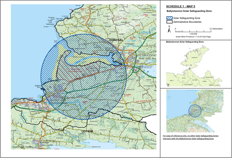
Map 5: Ballyshannon Solar Safeguarding Zone | ||
The area known as Ballyshannon Solar Safeguarding Zone is situated: | ||
(1) in the county of Donegal being the area enclosed on map 5 (contained in Schedule 1) within the inner margin of the blue line and hatched in blue and is situated in whole or in part in the townland[s] of: Abbey Island, Abbeylands, Ardfarn, Ballymacaward, Ballymunterhiggin, Boyannagh, Carrickboy, Creevy, Drumacrin, Dunmuckrum, Finner, Kildoney Glebe, Legaloscran, Magheracar, Portnason, Rathglass, Rathmore, Sheegys, Sminver, Tonregee, and Townparks, | ||
and | ||
(2) in the county of Leitrim being the area enclosed on map 5 (contained in Schedule 1) within the inner margin of the blue line and hatched in blue and is situated in whole or in part in the townland[s] of: Boyannagh. | ||
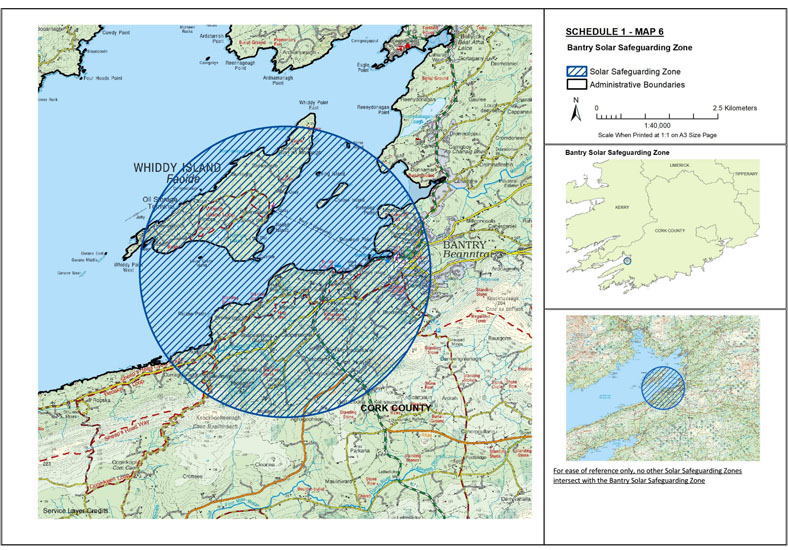
Map 6: Bantry Solar Safeguarding Zone | ||
The area known as Bantry Solar Safeguarding Zone is situated in the county of Cork being the area enclosed on map 6 (contained in Schedule 1) within the inner margin of the blue line and hatched in blue and is situated in whole or in part in the townland[s] of: Abbey, Aghagooheen, Ardyhoolihane, Beach, Boolteenagh, Cappanaloha East, Cappanaloha West, Carrignagat, Clashduff, Close, Crowkingle, Curraghavaddra, Dromacoosane, Dromclogh, Dromleigh North, Dromleigh South, Dromreague, Dunbittern East, Dunbittern West, Gortacloona, Gurraghy, Gurteen, Gurteenroe, Hollyhill, Keilnascarta, Kilmore, Kilnaruane, Kinathfineen, Knocknamuck, Lissareemig, Mullagh, Newtown, Reenaknock, Reenavanny, Reenrour East, Reenrour West, Seafield, Shanvallybeg, Sheskin, Tedagh, Town Lots, and Trawnahaha. | ||
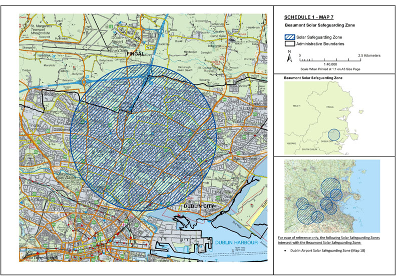
Map 7: Beaumont Solar Safeguarding Zone | ||
The area known as Beaumont Solar Safeguarding Zone is situated: | ||
(1) in the city of Dublin being the area enclosed on map 7 (contained in Schedule 1) within the inner margin of the blue line and hatched in blue and is situated in whole or in part in the electoral division[s] of: Ayrfield, Ballygall C, Ballymun B, Ballymun C, Ballymun D, Ballymun E, Beaumont A, Beaumont B, Beaumont C, Beaumont D, Beaumont E, Beaumont F, Botanic A, Botanic B, Clontarf East A, Clontarf East C, Clontarf East D, Clontarf East E, Clontarf West A, Clontarf West B, Clontarf West C, Clontarf West D, Clontarf West E, Drumcondra South A, Drumcondra South B, Drumcondra South C, Edenmore, Grace Park, Harmonstown A, Harmonstown B, Kilmore A, Kilmore B, Kilmore C, Kilmore D, Priorswood A, Priorswood B, Priorswood C, Priorswood D, Priorswood E, Whitehall A, Whitehall B, Whitehall C, and Whitehall D, | ||
and | ||
(2) in the county of Fingal being the area enclosed on map 7 (contained in Schedule 1) within the inner margin of the blue line and hatched in blue and is situated in whole or in part in the townland[s] of: Balcurris, Ballymun, Ballystruan, Belcamp, Clonshagh, Dardistown, Kilmore Big, Santry, Santry Demesne, Toberbunny, Turnapin Great, and Turnapin Little. | ||
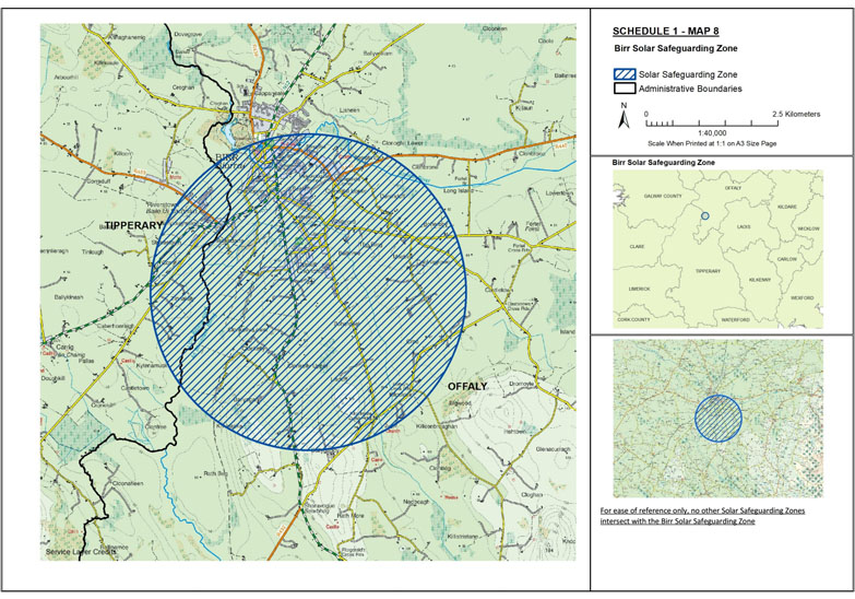
Map 8: Birr Solar Safeguarding Zone | ||
The area known as Birr Solar Safeguarding Zone is situated: | ||
(1) in the county of Offaly being the area enclosed on map 8 (contained in Schedule 1) within the inner margin of the blue line and hatched in blue and is situated in whole or in part in the townland[s] of: Ballindarra, Ballinree, Ballyegan, Ballygaddy, Boherboy, Boherdeel, Clonbrone, Clonkelly, Clonoghil Lower, Clonoghil Upper, Coolnagrower, Cree, Crinkill, Derrinduff, Drumbane, Kilcolman, Killeenbreaghan, Kilnalacka, Lisduff, Rath Beg Seefin, and Townparks, | ||
and | ||
(2) in the county of Tipperary being the area enclosed on map 8 (contained in Schedule 1) within the inner margin of the blue line and hatched in blue and is situated in whole or in part in the townland[s] of: Ballagh, Ballyloughnane, Caherhoereigh, Cornhill, Killeen, Kylenamuck, Stonestown, Tinlough, and Tinnakilly. | ||
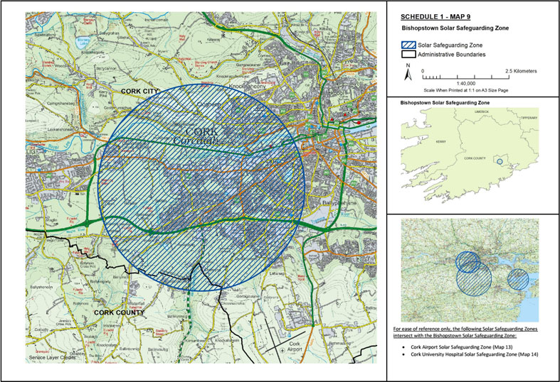
Map 9: Bishopstown Solar Safeguarding Zone | ||
The area known as Bishopstown Solar Safeguarding Zone is situated: | ||
(1) in the city of Cork being the area enclosed on map 9 (contained in Schedule 1) within the inner margin of the blue line and hatched in blue and is situated in whole or in part in the electoral division[s] of: Ballincollig, Bishopstown, Bishopstown A, Bishopstown B, Bishopstown C, Bishopstown D, Bishopstown E, Churchfield, Gillabbey A, Gillabbey B, Gillabbey C, Glasheen A, Glasheen B, Glasheen C, Greenmount, Gurranebraher A, Gurranebraher B, Inishkenny, Knocknaheeny, Lehenagh, Mardyke, Pouladuff A, Pouladuff B, Shanakiel, St. Mary’s, Sunday’s Well A, Sunday’s Well B, The Lough, Togher A, and Togher B, | ||
and | ||
(2) in the county of Cork being the area enclosed on map 9 (contained in Schedule 1) within the inner margin of the blue line and hatched in blue and is situated in whole or in part in the townland[s] of: Ballymah, Chetwynd, Knocknamallavoge, and Rochfordstown. | ||
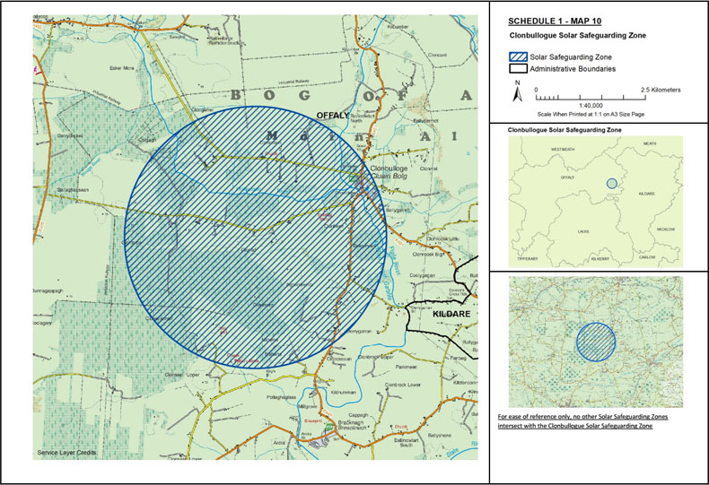
Map 10: Clonbullogue Solar Safeguarding Zone | ||
The area known as Clonbullogue Solar Safeguarding Zone is situated in the county of Offaly being the area enclosed on map 10 (contained in Schedule 1) within the inner margin of the blue line and hatched in blue and is situated in whole or in part in the townland[s] of: Aghameelick, Ballygarrett, Clonad, Clonavoe, Clonbulloge, Cloncassan, Cloncreen, Clongarret, Clonkeen, Clonmel, Clonmore, Clonsast Upper, Clonshannon, Colgagh, Derrygarran, Derrymore, and Nahana. | ||
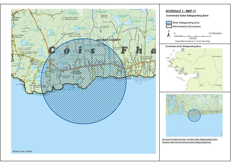
Map 11: Connemara Solar Safeguarding Zone | ||
The area known as Connemara Solar Safeguarding Zone is situated in the county of Galway being the area enclosed on map 11 (contained in Schedule 1) within the inner margin of the blue line and hatched in blue and is situated in whole or in part in the townland[s] of: Ballynahown North, Ballynahown South, Banraghbaun South, Cartron, Cartronlahan, Cloghmore North, Cloghmore South, Cornarona, Inveran, Minna, and Tully. | ||
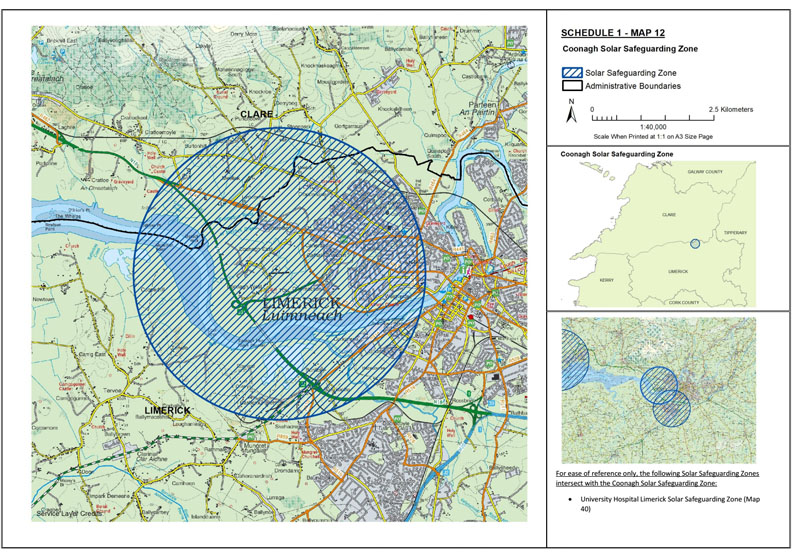
Map 12: Coonagh Solar Safeguarding Zone | ||
The area known as Coonagh Solar Safeguarding Zone is situated: | ||
(1) in the county of Clare being the area enclosed on map 12 (contained in Schedule 1) within the inner margin of the blue line and hatched in blue and is situated in whole or in part in the townland[s] of: Bullsfarm, Burtonhill, Cratloe, Cratloekeel, Cratloemoyle, Gortgarraun, Meelick, Pass, Punchbowl, and Stonepark, | ||
and | ||
(2) in the county of Limerick being the area enclosed on map 12 (contained in Schedule 1) within the inner margin of the blue line and hatched in blue and is situated in whole or in part in the townland[s] of: Ballinacurra (Hart), Ballygrennan, Ballykeeffe, Ballynanty Beg, Ballynanty More, Bunlicky, Caherdavin, Castlemungret, Clonconane, Clondrinagh, Clonmacken, Conigar, Coolraine, Coonagh East, Coonagh West, Cooperhill, Corkanree, Courtbrack, Farranshone Beg, Farranshone More, Kilrush, Knock, Moylish, Prior’s Land, Shannabooly, Skehacreggaun, and Tervoe. | ||
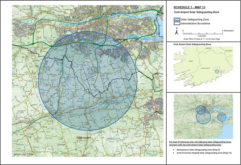
Map 13: Cork Airport Solar Safeguarding Zone | ||
The area known as Cork Airport Solar Safeguarding Zone is situated: | ||
(1) in the city of Cork being the area enclosed on map 13 (contained in Schedule 1) within the inner margin of the blue line and hatched in blue and is situated in whole or in part in the electoral division[s] of: Ballygarvan, Ballyphehane A, Ballyphehane B, Bishopstown, Bishopstown B, Bishopstown C, Bishopstown D, Bishopstown E, Douglas, Glasheen A, Glasheen B, Glasheen C, Inishkenny, Lehenagh, Pouladuff A, Pouladuff B, The Lough, Togher A, Togher B, Tramore C, Turner’s Cross C, and Turner’s Cross D, | ||
and | ||
(2) in the county of Cork being the area enclosed on map 13 (contained in Schedule 1) within the inner margin of the blue line and hatched in blue and is situated in whole or in part in the townland[s] of: Adamstown, Ballea, Ballinaboy, Ballincranig, Ballinphelic, Ballinrea, Ballinrea South, Ballinreeshig, Ballintannig, Ballinvoultig, Ballinvrinsig, Ballyduhig South, Ballygarvan, Ballymah, Ballynabearna, Ballynagrumoolia, Ballynoe, Chetwynd, Glinny, Gogganshill, Inishkenny, Killanully, Kilmurriheen, Kilnahone, Kingsland, Knockalisheen, Knocknalyre, Knocknamallavoge, Lisfehill, Liskillea, Meadstown, Rearour And Barrettshill, Rochfordstown, Shanagraigue, Tullig Beg, and Tullig More. | ||
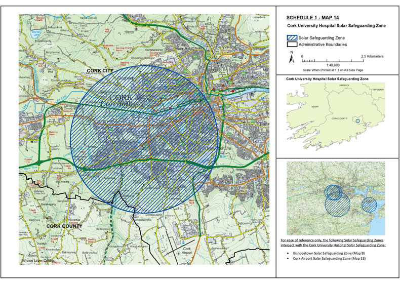
Map 14: Cork University Hospital Solar Safeguarding Zone | ||
The area known as Cork University Hospital Solar Safeguarding Zone is situated: | ||
(1) in the city of Cork being the area enclosed on map 14 (contained in Schedule 1) within the inner margin of the blue line and hatched in blue and is situated in whole or in part in the electoral division[s] of: Ballincollig, Ballyphehane A, Ballyphehane B, Bishopstown, Bishopstown A, Bishopstown B, Bishopstown C, Bishopstown D, Bishopstown E, Centre A, Centre B, Churchfield, Evergreen, Fair Hill A, Gillabbey A, Gillabbey B, Gillabbey C, Glasheen A, Glasheen B, Glasheen C, Greenmount, Gurranebraher A, Gurranebraher B, Gurranebraher C, Gurranebraher D, Gurranebraher E, Inishkenny, Knocknaheeny, Lehenagh, Mardyke, Pouladuff A, Pouladuff B, Shanakiel, Shandon B, South Gate A, South Gate B, St. Mary’s, Sunday’s Well A, Sunday’s Well B, The Lough, Togher A, Togher B, Turner’s Cross A, Turner’s Cross B, Turner’s Cross C, and Turner’s Cross D, | ||
and | ||
(2) in the county of Cork being the area enclosed on map 14 (contained in Schedule 1) within the inner margin of the blue line and hatched in blue and is situated in whole or in part in the townland[s] of: Chetwynd, Knocknamallavoge, and Rochfordstown. | ||
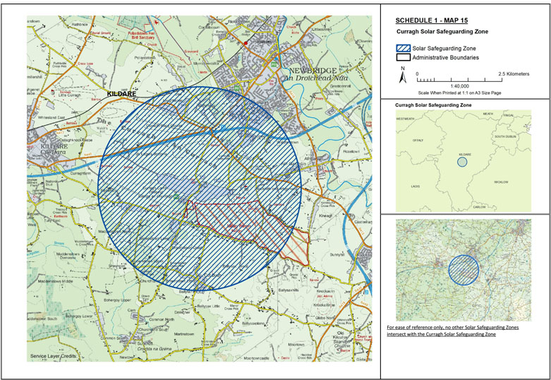
Map 15: Curragh Solar Safeguarding Zone | ||
The area known as Curragh Solar Safeguarding Zone is situated in the county of Kildare being the area enclosed on map 15 (contained in Schedule 1) within the inner margin of the blue line and hatched in blue and is situated in whole or in part in the townland[s] of: Ballyfair, Ballymany, Ballysax Great, Ballysax Little, Ballysaxhills, Blackrath and Athgarvan, Brownstown Great, Brownstown Little, Brownstown Lower, Brownstown Upper, Crotanstown, Curragh, Curraghfarm, Loughbrown, Maddenstown North, Moorfield, Morristownbiller, Pollardstown, Sheshoon, Strawhall, Tully East, and Walshestown. | ||
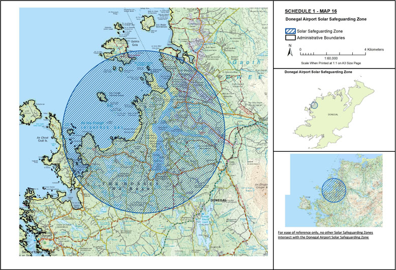
Map 16: Donegal Airport Solar Safeguarding Zone | ||
The area known as Donegal Airport Solar Safeguarding Zone is situated in the county of Donegal being the area enclosed on map 16 (contained in Schedule 1) within the inner margin of the blue line and hatched in blue and is situated in whole or in part in the townland[s] of: Annagary, Ardnagappary, Belcruit, Braade, Bunbeg, Carnboy, Carrickfin, Crolly, Cruit Lower, Cruit Upper, Derrybeg, Derrynamansher, Dore, Drumnacart, Drumnacart Mountain Pasture, Dunmore, Gola, Gortnasate, Inishinny, Killindarragh, Kincaslough, Knockastoller, Magheraclogher, Magheragallan, Meenaduff, Meenalecky, Meenanillar, Meenbannad, Meenderrynasloe, Meenderryowan, Mullaghderg, Mullaghderg Mountain Pasture, Mullaghdoo Irish, Mullaghdoo Scotch, and Rinnafarset. | ||
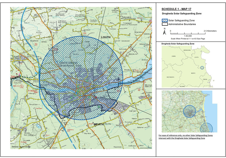
Map 17: Drogheda Solar Safeguarding Zone | ||
The area known as Drogheda Solar Safeguarding Zone is situated: | ||
(1) in the county of Louth being the area enclosed on map 17 (contained in Schedule 1) within the inner margin of the blue line and hatched in blue and is situated in whole or in part in the townland[s] of: Bailypark, Ballsgrove, Ballymakenny , Beaulieu, Bryanstown, Carntown, Commons, Greenbatter, Killineer, Lagavooren, Liscorry, Listoke, Mell, Moneymore, Newtown, Newtownstalaban, Philipstown, Rathmullan, Stagreenan, Stameen, Townrath, Tullyallen, Twenties, and Yellowbatter, | ||
and | ||
(2) in the county of Meath being the area enclosed on map 17 (contained in Schedule 1) within the inner margin of the blue line and hatched in blue and is situated in whole or in part in the townland[s] of: Bey Beg, Bey More, Bryanstown, Colp West, Lagavooren, Oldbridge, Rathmullan, Sheephouse, Stagreenan, and Stameen. | ||
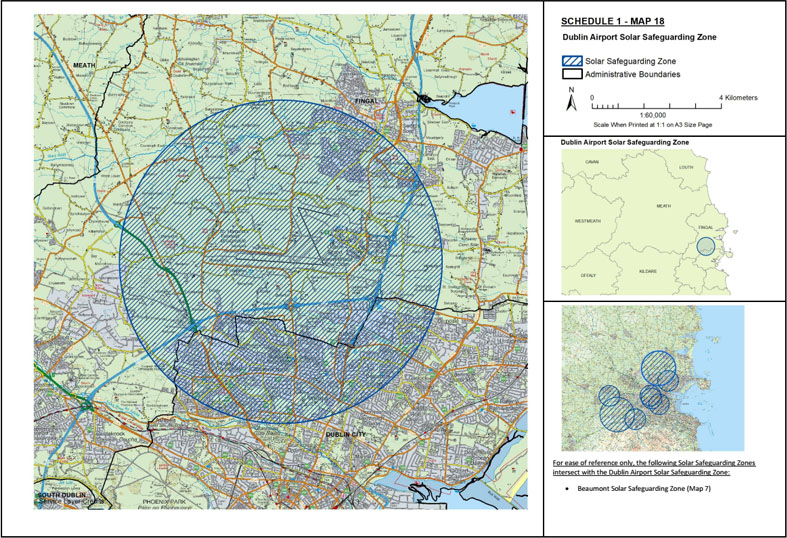
Map 18: Dublin Airport Solar Safeguarding Zone | ||
The area known as Dublin Airport Solar Safeguarding Zone is situated: | ||
(1) in the city of Dublin being the area enclosed on map 18 (contained in Schedule 1) within the inner margin of the blue line and hatched in blue and is situated in whole or in part in the electoral division[s] of: Ballygall A, Ballygall B, Ballygall C, Ballygall D, Ballymun A, Ballymun B, Ballymun C, Ballymun D, Ballymun E, Ballymun F, Beaumont A, Beaumont B, Beaumont F, Blanchardstown-Abbotstown, Botanic A, Drumcondra South C, Finglas North A, Finglas North B, Finglas North C, Finglas South A, Finglas South B, Finglas South C, Grace Park, Kilmore A, Kilmore B, Ballygall A, Ballygall B, Ballygall C, Ballygall D, Ballymun A, Ballymun B, Ballymun C, Ballymun D, Ballymun E, Ballymun F, Beaumont A, Beaumont B, Beaumont F Blanchardstown-Abbotstown, Botanic A, Drumcondra South C, Finglas North A, Finglas North B, Finglas North C, Finglas South A, Finglas South B, Finglas South C, Grace Park, Kilmore A, Kilmore B, Kilmore C, Kilmore D, Priorswood A, Priorswood B, Priorswood D, Priorswood E, Whitehall A, Whitehall B, and Whitehall C, | ||
and | ||
(2) in the county of Fingal being the area enclosed on map 18 (contained in Schedule 1) within the inner margin of the blue line and hatched in blue and is situated in whole or in part in the townland[s] of: Balcurris, Ballymacartle, Ballymun, Ballystrahan, Ballystruan, Balseskin, Barberstown, Barrysparks, Baskin, Belcamp, Bishopswood, Brackenstown, Brazil, Broghan, Burgage, Cappoge, Charlestown, Cherryhound, Cloghran, Clonshagh, Coldwinters, Collinstown, Common, Commons, Commons West, Corballis, Corrstown, Coultry, Cremona, Crowscastle, Dardistown, Drinan, Dubber, Dunbro, Dunsoghly, Forrest Great, Forrest Little, Forrestfields, Fosterstown North, Fosterstown South, Glebe, Grange, Greenwood, Harristown, Hilltown, Huntstown, Jamestown Little, Johnstown, Kildonan, Killeek, Kilmacree, Kilmore Big, Kilreesk, Kilshane, Kingstown, Knocksedan, Laurestown, Leas, Marshallstown, Meakstown, Merryfalls, Middletown, Millhead, Miltonsfields, Mitchelstown, Mooretown, Mountambrose Great, Nevinstown East, Nevinstown West, Newpark, Newtown, Pickardstown, Poppintree, Portmellick, Rahulk, Rathbeal, Rathingle, Rock, Sandyhill, Santry, Santry Demesne, Shallon, Shanganhill, Silloge, Skephubble, Springhill, St. Margaret’s, Stockhole, Surgalstown South, Swords Glebe, Toberbunny, Toberburr, Townparks, Turnapin Great, Turnapin Little, Ward Upper, Westereave, and Windmill Lands. | ||
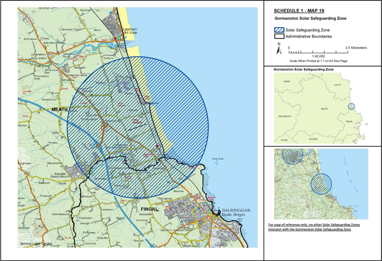
Map 19: Gormanston Solar Safeguarding Zone | ||
The area known as Gormanston Solar Safeguarding Zone is situated: | ||
(1) in the county of Fingal being the area enclosed on map 19 (contained in Schedule 1) within the inner margin of the blue line and hatched in blue and is situated in whole or in part in the townland[s] of: Balscaddan, Bremore, Commons (2nd Division), Drummans, Flemingtown, Gormanston Demesne, Knocknagin, Rath, Stamullin, Tobersool, and Tobertown, | ||
and | ||
(2) in the county of Meath being the area enclosed on map 19 (contained in Schedule 1) within the inner margin of the blue line and hatched in blue and is situated in whole or in part in the townland[s] of: Balloy, Ballygarth, Briarleas, Claristown, Corballis, Gormanston, Irishtown, Keenoge, Mosney, Richardstown, Sarsfieldstown, and Stamullin. | ||
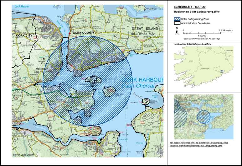
Map 20: Haulbowline Solar Safeguarding Zone | ||
The area known as Haulbowline Solar Safeguarding Zone is situated in the county of Cork being the area enclosed on map 20 (contained in Schedule 1) within the inner margin of the blue line and hatched in blue and is situated in whole or in part in the townland[s] of: Ballintaggart, Ballybricken, Ballyleary, Ballynacrusha, Ballynoe, Ballyvoloon, Ballywilliam, Barnahely, Carrignafoy, Curraghbinny, Cuskinny, Dean and Chapter Land of Cloyne, Kilgarvan, Lackaroe, Loughbeg, Monkstown, Monkstown (Castle Farm), Parkgarriff, Raheens, Raheens East, Rathanker, Ringacoltig, Ringaskiddy, Ringmeen, Shanbally, Spike Island, and Tiknock. | ||
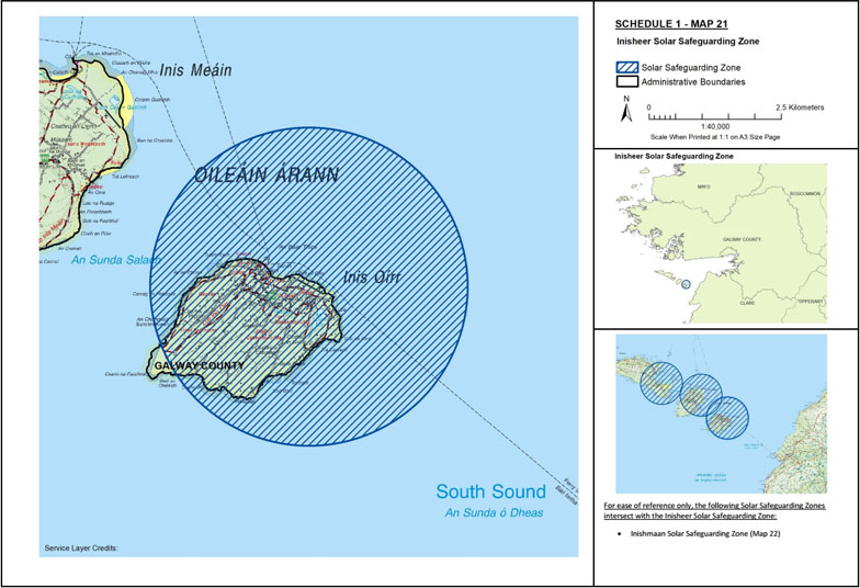
Map 21: Inisheer Solar Safeguarding Zone | ||
The area known as Inisheer Solar Safeguarding Zone is situated in the county of Galway being the area enclosed on map 21 (contained in Schedule 1) within the inner margin of the blue line and hatched in blue and is situated in whole or in part in the townland[s] of: Inisheer. | ||
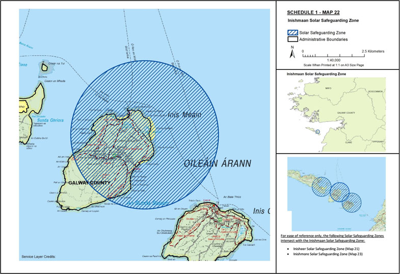
Map 22: Inishmaan Solar Safeguarding Zone | ||
The area known as Inishmaan Solar Safeguarding Zone is situated in the county of Galway being the area enclosed on map 22 (contained in Schedule 1) within the inner margin of the blue line and hatched in blue and is situated in whole or in part in the townland[s] of: Carrownlisheen, and Carrowntemple. | ||
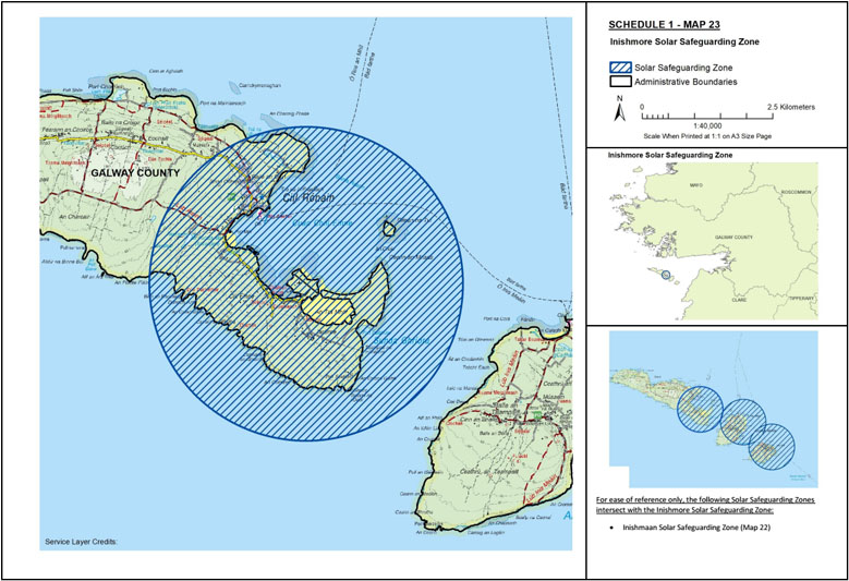
Map 23: Inishmore Solar Safeguarding Zone | ||
The area known as Inishmore Solar Safeguarding Zone is situated in the county of Galway being the area enclosed on map 23 (contained in Schedule 1) within the inner margin of the blue line and hatched in blue and is situated in whole or in part in the townland[s] of: Killeany, and Oghil. | ||
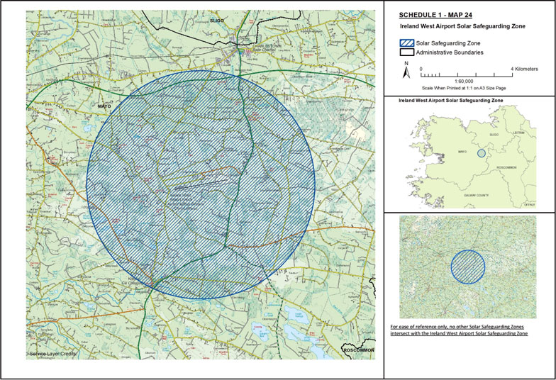
Map 24: Ireland West Airport Solar Safeguarding Zone | ||
The area known as Ireland West Airport Solar Safeguarding Zone is situated in the county of Mayo being the area enclosed on map 24 (contained in Schedule 1) within the inner margin of the blue line and hatched in blue and is situated in whole or in part in the townland[s] of: Ballyglass, Ballyglass East, Ballyglass West, Barcull, Barnacahoge, Barnalyra, Bracklagh, Bulcaun, Carn, Carrowbeg, Cartron, Cashel, Cloonalison, Cloonlyon, Cloonnamna, Cornaveagh, Curryaun, Derragh, Derrynaleck, Derryronan, Falleighter, Glenmullynaha East, Glenmullynaha West, Glentavraun, Gowlaun, Kilgarriff West, Kilkelly, Killaturly, Killeen, Kilmore, Knockbrack, Knockranny, Lecarrow, Liscosker, Lowpark, Lurga Lower, Lurga Upper, Mullenmadoge, Puntabeg, Ranaranny, Shammerbaun, Shammerdoo, Sonnagh, Sonvolaun, Stripe, Tavraun, Tawnyinah Lower, Tawnyinah Middle, Tawnyinah Upper, Temple, Tomboholla, Treanacally or Hagfield, Trouthill or Knockbrack, Tullynahoo, and Uggool. | ||
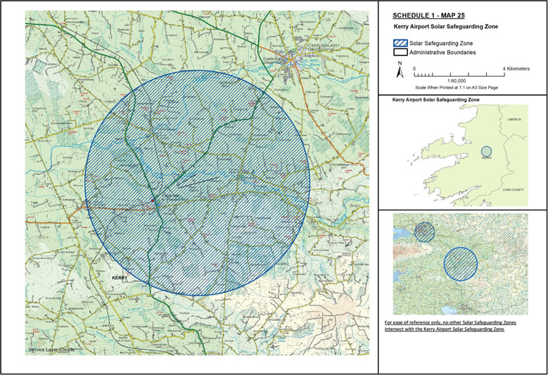
Map 25: Kerry Airport Solar Safeguarding Zone | ||
The area known as Kerry Airport Solar Safeguarding Zone is situated in the county of Kerry being the area enclosed on map 25 (contained in Schedule 1) within the inner margin of the blue line and hatched in blue and is situated in whole or in part in the townland[s] of: Anna Beg, Anna More, Ardcrone, Ballinvariscal, Ballinvarrig, Ballybane, Ballybeg, Ballygree, Ballymacdonnell, Ballymacpierce, Beenateevaun, Boherboy, Bohereens, Boolacullane, Bushmount, Camp, Castlefarm, Clashganniv, Cliddaun, Cloonacurrig, Cloonclogh, Cloonlara, Cloontarriv, Coollick, Coolnacalliagh, Corbally, Crag, Currabanefield, Curracitty, Curraknockaun, Curraross, Dicksgrove, Dromroe, Dromultan, Farran, Farranamranagh, Farrandoctor, Farranfore, Farrankeal, Garraundarragh, Gearha, Glanbane, Gortalassa, Gortshanavogh, Gowlane, Graffeens, Gurteenroe, Inchinveema, Kilcow, Kilfallinga, Kilfelim, Killahane, Killeagh, Killeentierna, Knockaderry, Laharan, Leamnaguila, Lisheenbaun, Lissataggle, Loughnagore, Lyre, Meanus, Parknamulloge, Parknasmuttaun, Ranaleen, Ranalough, Reavaun, Rossanean, Rossmore, Roxborough, Scart, Shanawillen, Skahies, Springmount, Toornanoulagh and Urrohogal. | ||
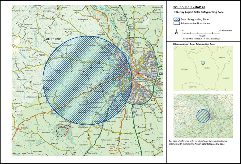
Map 26: Kilkenny Airport Solar Safeguarding Zone | ||
The area known as Kilkenny Airport Solar Safeguarding Zone is situated in the county of Kilkenny being the area enclosed on map 26 (contained in Schedule 1) within the inner margin of the blue line and hatched in blue and is situated in whole or in part in the townland[s] of: Archersleas, Ardboy, Ardscradaun, Aughtanny, Ayresfields, Ballyhendricken, Barrackhill (Cranesborough), Baunreagh, Bigbog, Bishop’s Demesne, Bishopsfurze, Bishopsmeadows, Bonnetstown, Burntfurze, Cappagh, Cashel, Castleblunden, Castleinch or Inchyolaghan, Cloghoge, Clonmoran, Coolgrange, Crokershill, Damma Lower, Damma Upper, Deerpark, Derdimus, Dicksborough, Donaghmore, Drakeland Lower, Drakeland Middle, Drakeland Upper, Dunningstown, Friarsinch, Gardens, Goslingstown, Holdensrath, Jamesgreen, Jamespark, Keatingstown, Kilcreen, Kylebeg, Kylenasaggart, Lacken, Loughmacask, Lousybush, Lyons, Maidenhill, Margaret’s Fields, Marnellsmeadows, Mortgage Fields, Newtown, Oldpark, Palmerstown, Poulgour, Raheennagun, Reviewfields, Robertshill, Shellumsrath, Smithsland North, Sugarloafhill, Talbotsinch, Walkinslough, and Wetland. | ||
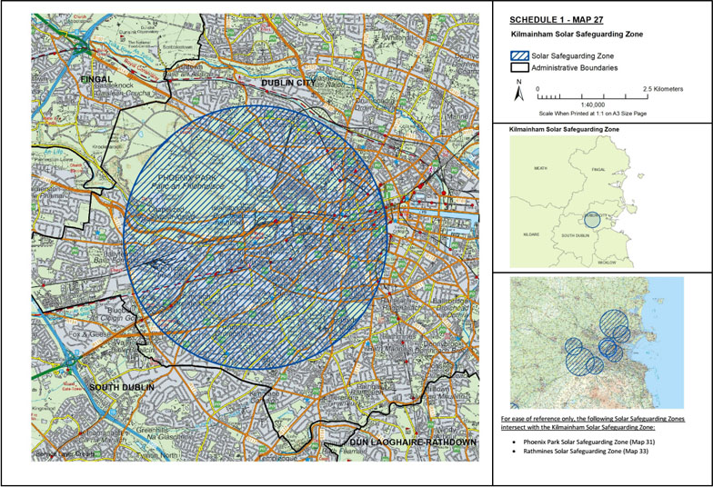
Map 27: Kilmainham Solar Safeguarding Zone | ||
The area known as Kilmainham Solar Safeguarding Zone is situated in the city of Dublin being the area enclosed on map 27 (contained in Schedule 1) within the inner margin of the blue line and hatched in blue and is situated in whole or in part in the electoral division[s] of: Arran Quay A, Arran Quay B, Arran Quay C, Arran Quay D, Arran Quay E, Ashtown A, Ashtown B, Cabra East A, Cabra East B, Cabra East C, Cabra West A, Cabra West B, Cabra West C, Cabra West D, Chapelizod, Crumlin A, Crumlin B, Crumlin C, Crumlin D, Crumlin E, Crumlin F, Decies, Drumfinn, Inchicore A, Inchicore B, Inns Quay A, Inns Quay B, Inns Quay C, Kilmainham A, Kilmainham B, Kilmainham C, Kimmage A, Kimmage B, Kimmage C, Kimmage D, Kimmage E, Kylemore, Mansion House A, Mansion House B, Merchants Quay A, Merchants Quay B, Merchants Quay C, Merchants Quay D, Merchants Quay E, Merchants Quay F, North City, Phoenix Park, Rathmines West A, Rathmines West F, Rotunda A, Rotunda B, Royal Exchange A, Royal Exchange B, Saint Kevin’s, Terenure A, Ushers A, Ushers B, Ushers C, Ushers D, Ushers E, Ushers F, Walkinstown A, Walkinstown B, Walkinstown C, Wood Quay A, and Wood Quay B. | ||
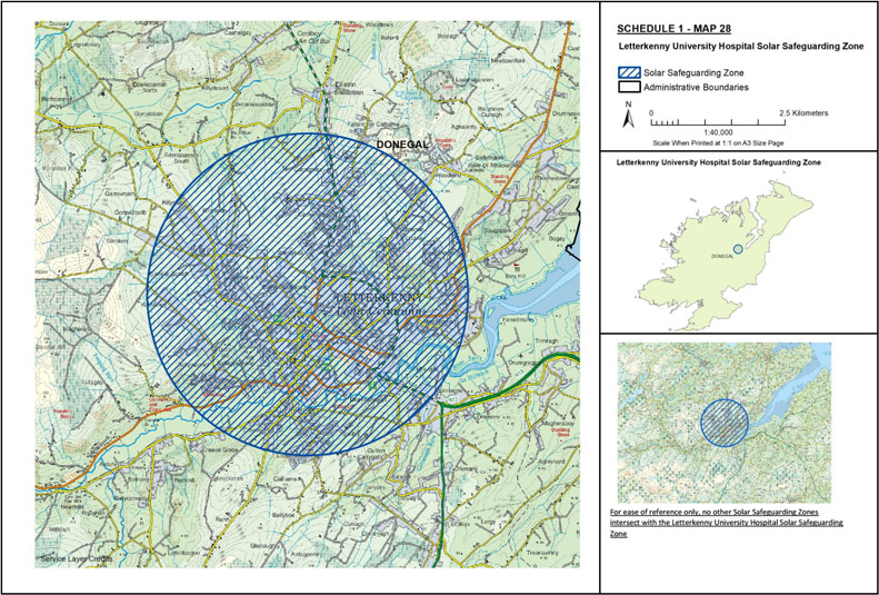
Map 28: Letterkenny University Hospital Solar Safeguarding Zone | ||
The area known as Letterkenny University Hospital Solar Safeguarding Zone is situated in the county of Donegal being the area enclosed on map 28 (contained in Schedule 1) within the inner margin of the blue line and hatched in blue and is situated in whole or in part in the townland[s] of: Ardarawer, Ballaghderg, Ballyboe Glencar, Ballyboe Lisnenan, Ballymacool, Ballyraine, Bellanascaddan, Bunnagee, Carnamogagh Lower, Carnamogagh Upper, Castlebane, Conwal, Coolboy Little, Creeve (Smith), Creeve Glebe, Cullion, Curraghlea, Drumnahoagh, Edenacarnan South, Fallard or Calhame, Glebe, Glencar Irish, Glencar Scotch, Gortlee, Gortnacorrib, Killyclug, Killylastin, Kiltoy, Kirkstown, Knocknamona, Knockybrin, Letterkenny, Lismonaghan, Lisnenan, Loughnagin, Magheran, Magheranan, Milk Isle, Oldtown, Sallaghagrane, Scribly, Windyhall, Woodland, and Woodpark. | ||
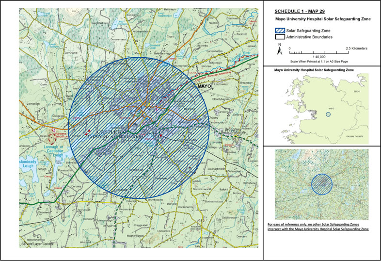
Map 29: Mayo University Hospital Solar Safeguarding Zone | ||
The area known as Mayo University Hospital Solar Safeguarding Zone is situated in the county of Mayo being the area enclosed on map 29 (contained in Schedule 1) within the inner margin of the blue line and hatched in blue and is situated in whole or in part in the townland[s] of: Aghadrinagh, Aghalusky, Annalecka, Balloor, Ballymacrah, Ballynaboll North, Ballynaboll South, Ballynacarriga, Carn, Carrowbrinoge, Carrowncurry, Cloonagh, Cloondeash, Coarsepark, Cornanool, Corradrish, Cottage, Creeragh, Curragh, Curry, Derreenmanus, Derreenmulroy, Derrinlevaun, Derrycoosh, Derrynaskeagh, Derryool, Doogary, Drumaleheen, Drumask, Drumconlan, Drumkeaghta, Drumnacarta, Drumneen, Drumshinnagh, Garryduff, Gorteendrunagh, Graffa Beg, Hawthornlodge, Kilkenny, Knockacroghery, Knockaphunta, Knockrawer, Knockthomas, Lagnavaddoge, Lightford, Liscromwell, Lisnageeha or Antigua, Lisnakirka or Milebush, Moneenbradagh, Mountgregory, Newantrim, Rathbaun, Rinshinna, Saleen, Shanvally, Snugborough, Springfield, Struaun, Tawnycoolawee, Tully and Tully Commons. | ||
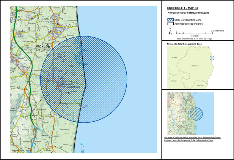
Map 30: Newcastle Solar Safeguarding Zone | ||
The area known as Newcastle Solar Safeguarding Zone is situated in the county of Wicklow being the area enclosed on map 30 (contained in Schedule 1) within the inner margin of the blue line and hatched in blue and is situated in whole or in part in the townland[s] of: Ballycrone, Ballyloughlin, Ballyphilip, Ballyvolan Lower, Barnacoyle Big, Blackditch, Cooldross Lower, Cooldross Middle, Grange North, Grange South, Leabeg Lower, Leabeg Middle, Leabeg Upper, Leamore Lower, Leamore Upper, Newcastle Lower, Newcastle Middle, Newcastle Upper, Slate, Tiglin, and Woodstock Demesne. | ||
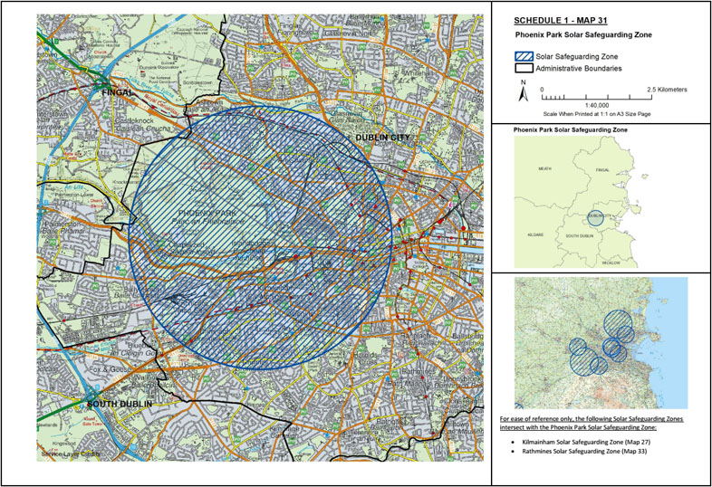
Map 31: Phoenix Park Solar Safeguarding Zone | ||
The area known as Phoenix Park Solar Safeguarding Zone is situated: | ||
(1) in the city of Dublin being the area enclosed on map 31 (contained in Schedule 1) within the inner margin of the blue line and hatched in blue and is situated in whole or in part in the electoral division[s] of: Arran Quay A, Arran Quay B, Arran Quay C, Arran Quay D, Arran Quay E, Ashtown A, Ashtown B, Botanic A, Botanic C, Cabra East A, Cabra East B, Cabra East C, Cabra West A, Cabra West B, Cabra West C, Cabra West D, Chapelizod, Crumlin A, Crumlin B, Crumlin C, Crumlin D, Crumlin E, Crumlin F, Decies, Drumfinn, Finglas South B, Finglas South C, Inchicore A, Inchicore B, Inns Quay A, Inns Quay B, Inns Quay C, Kilmainham A, Kilmainham B, Kilmainham C, Kimmage A, Kimmage B, Kimmage C, Kylemore, Merchants Quay A, Merchants Quay B, Merchants Quay C, Merchants Quay D, Merchants Quay E, Merchants Quay F, North City, Phoenix Park, Rotunda A, Rotunda B, Royal Exchange A, Ushers A, Ushers B, Ushers C, Ushers F, Ushers D, Ushers E, Walkinstown A, Walkinstown B, Wood Quay A, and Wood Quay B, | ||
and | ||
(2) in the county of Fingal being the area enclosed on map 31 (contained in Schedule 1) within the inner margin of the blue line and hatched in blue and is situated in whole or in part in the townland[s] of: Ashtown, Castleknock, and Pelletstown. | ||
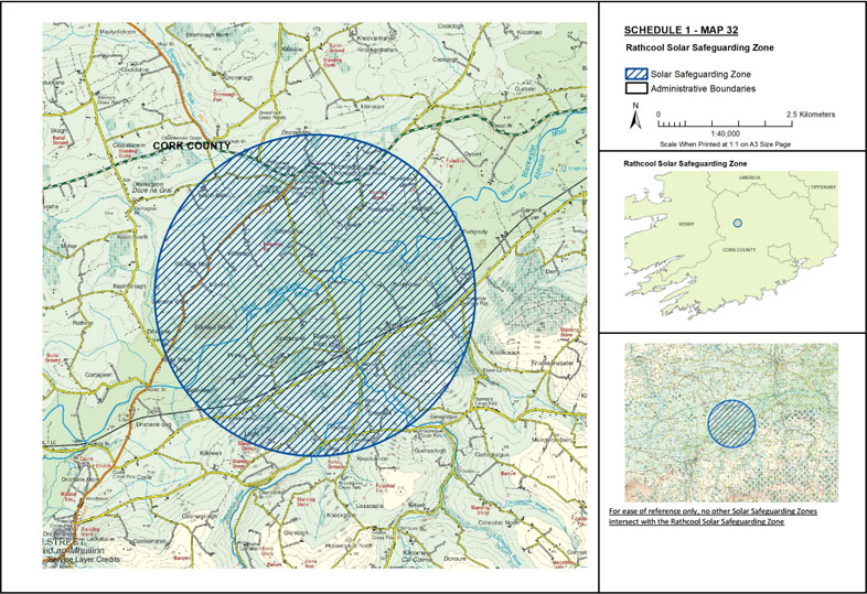
Map 32: Rathcool Solar Safeguarding Zone | ||
The area known as Rathcool Solar Safeguarding Zone is situated in the county of Cork being the area enclosed on map 32 (contained in Schedule 1) within the inner margin of the blue line and hatched in blue and is situated in whole or in part in the townland[s] of: Ballinkeen, Boolymore, Carragraigue, Dromagh, Dromahoe, Drombeg, Drominagh South, Dromskehy, Dromtarriff, Ducleagh, Fortgrady, Garrane North, Garrane South, Garrane West, Glenleigh, Island-Dahill, Keale South, Kilcorney, Killetragh, Kippagh, Knockanroe, Knockbrack, Knockcahill, Laght, Lisnacon, Minehill, Prohus, Rathcool, Rossglass, and Shanakill. | ||
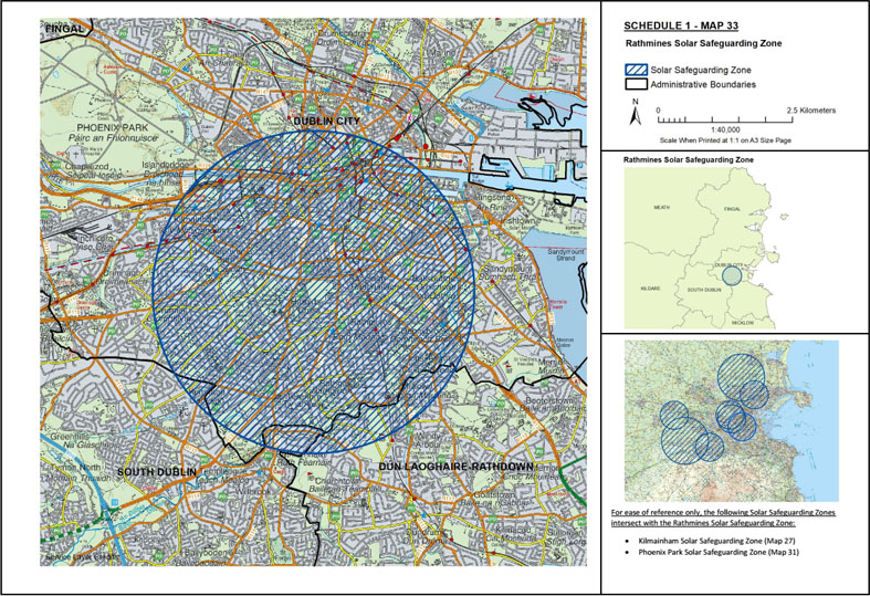
Map 33: Rathmines Solar Safeguarding Zone | ||
The area known as Rathmines Solar Safeguarding Zone is situated: | ||
(1) in the city of Dublin being the area enclosed on map 33 (contained in Schedule 1) within the inner margin of the blue line and hatched in blue and is situated in whole or in part in the electoral division[s] of: Arran Quay B, Arran Quay E, Arran Quay D, Arran Quay C, Crumlin A, Crumlin B, Crumlin C, Crumlin D, Crumlin E, Crumlin F, Inns Quay B, Inns Quay C, Kilmainham B, Kilmainham C, Kimmage A, Kimmage B, Kimmage C, Kimmage D, Kimmage E, Mansion House A, Mansion House B, Merchants Quay A, Merchants Quay B, Merchants Quay C, Merchants Quay E, Merchants Quay F, Mountjoy A, North City, North Dock C, Pembroke East B, Pembroke East D, Pembroke East E, Pembroke West A, Pembroke West B, Pembroke West C, Phoenix Park, Rathfarnham, Rathfarnham Village, Rathmines East A, Rathmines East B, Rathmines East C, Rathmines East D, Rathmines West A, Rathmines West B, Rathmines West C, Rathmines West D, Rathmines West E, Rathmines West F, Rotunda A, Rotunda B, Royal Exchange A, Royal Exchange B, Saint Kevin’s, South Dock, Terenure A, Terenure B, Terenure C, Terenure D, Ushers A, Ushers B, Ushers C, Ushers D, Ushers E, Ushers F, Wood Quay A, and Wood Quay B, | ||
and | ||
(2) in the county of Dún Laoghaire-Rathdown being the area enclosed on map 33 (contained in Schedule 1) within the inner margin of the blue line and hatched in blue and is situated in whole or in part in the townland[s] of: Farranboley, Newtown Little, Rathfarnham, Rathmines Great, Rathmines Little, and Roebuck, | ||
and | ||
(3) in the county of South Dublin being the area enclosed on map 33 (contained in Schedule 1) within the inner margin of the blue line and hatched in blue and is situated in whole or in part in the townland[s] of: Crumlin, Kimmage, and Rathfarnham. | ||
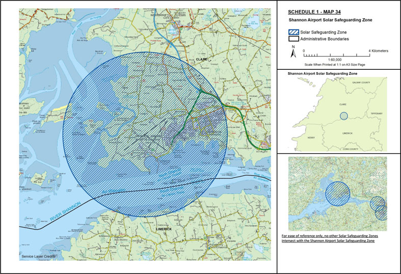
Map 34: Shannon Airport Solar Safeguarding Zone | ||
The area known as Shannon Airport Solar Safeguarding Zone is situated: | ||
(1) in the county of Clare being the area enclosed on map 34 (contained in Schedule 1) within the inner margin of the blue line and hatched in blue and is situated in whole or in part in the townland[s] of: Ballinooskny, Ballycally, Ballycasey Beg, Ballycasey More, Ballyhennessy, Ballymacnevin, Ballymurtagh, Breckinish, Caherteige, Carrigerry, Carrow, Carrowbane, Clenagh, Clonloghan, Clonmoney West, Coney Island, Culleen, Drumgeely, Drumline, Feenish, Garrynamona, Inishmacnaghtan, Islandmacnevin, Killulla, Kilmaleery, Knockaun, Leamaneigh Beg, Leamaneigh More, Lisconor, Lismacleane, Rineanna North, Rineanna South, Smithstown, Stonehall, Treannahow, Tullyglass, Tullyvarraga, Urlan Beg, and Urlan More, | ||
and | ||
(2) in the county of Limerick being the area enclosed on map 34 (contained in Schedule 1) within the inner margin of the blue line and hatched in blue and is situated in whole or in part in the townland[s] of: Ballinvoher, Ballymartin, Ballynacourty, Beagh, Bushyisland, Castletown, Ringmoylan, and Shannongrove. | ||
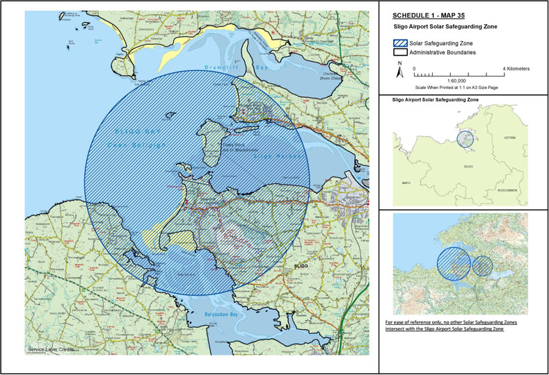
Map 35: Sligo Airport Solar Safeguarding Zone | ||
The area known as Sligo Airport Solar Safeguarding Zone is situated in the county of Sligo being the area enclosed on map 35 (contained in Schedule 1) within the inner margin of the blue line and hatched in blue and is situated in whole or in part in the townland[s] of: Ballinlig, Ballinphull, Ballybeg, Ballyweelin, Barnasrahy, Buninna, Carrowbrickeen, Carrowbunnaun, Carrowdough, Carrowloughan East, Carrowloughan West, Carrownteane, Carrowreagh, Cartron (Honoria Duff), Creggyconnell, Culleenamore, Culleenduff, Cummeen, Derk Beg, Derk More, Drinaghan, Falfin, Fallathurteen, Glen, Grange East, Grange North, Grange West, Inishmulclohy or Coney Island, Killaspugbrone, Knocknarea North, Knocknarea South, Larass or Strandhill, Lecarrow, Lisheenacooravan, Lissawully, Luffertan, Maguins Island, Portavaud, Primrosegrange, Rathcarrick, Rathonoragh, Rinn, Rosses Lower, Rosses Upper, Scardan Beg, Scardan More, Seafield, Skibbolecorragh Slieveroe or Siberia, Tully, and Woodpark. | ||
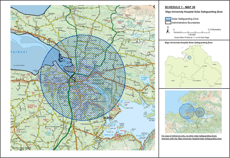
Map 36: Sligo University Hospital Solar Safeguarding Zone | ||
The area known as Sligo University Hospital Solar Safeguarding Zone is situated in the county of Sligo being the area enclosed on map 36 (contained in Schedule 1) within the inner margin of the blue line and hatched in blue and is situated in whole or in part in the townland[s] of: Abbeyquarter North, Abbeyquarter South, Ballincar, Ballinvoher, Ballydoogan, Ballyfree, Ballyglass, Ballytivnan, Barroe, Bellanode, Caltragh, Carncash, Carns, Carns (Duke), Carrowroe, Cartron, Cleaveragh Demesne, Commons, Cornageeha, Derrydarragh or Oakfield, Doonally, Farranacardy, Faughts, Finisklin, Hazelwood Demesne, Kiltycahill, Knappagh Beg, Knappagh More, Knocknaganny, Lisgorey, Lisnalurg, Magheraboy, Rathbraghan, Rathedmond, Rathquarte, Shannon Eighter, Shannon Oughter, Teesan, Tonaphubble, Tullynagracken North, and Tullynagracken South. | ||
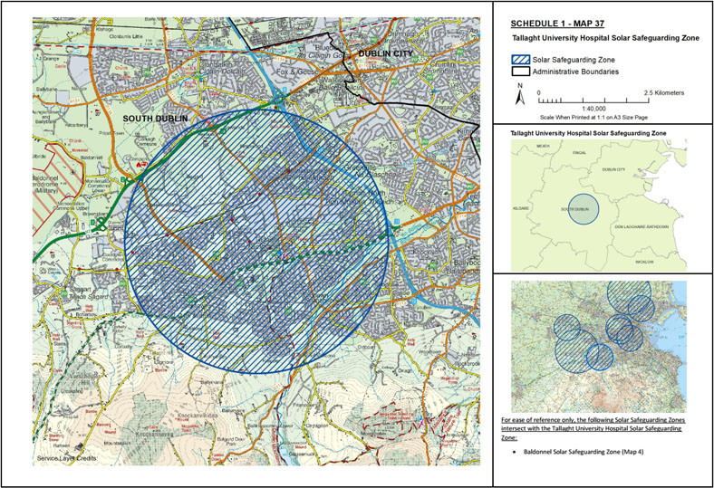
Map 37: Tallaght University Hospital Solar Safeguarding Zone | ||
The area known as Tallaght University Hospital Solar Safeguarding Zone is situated in the county of South Dublin being the area enclosed on map 37 (contained in Schedule 1) within the inner margin of the blue line and hatched in blue and is situated in whole or in part in the townland[s] of: Ashfield, Ballycragh, Ballymana, Ballymount Great, Ballymount Little, Bedlesshill, Belgard, Bohernabreena, Brideswell Commons, Brownsbarn, Buckandhounds, Bushelloaf, Cheeverstown, Clondalkin, Cookstown, Corbally, Corkagh, Corkagh Demesne, Fortunestown, Friarstown Upper, Garranstown or Kingswood, Gibbons, Jobstown, Killinardan, Killininny, Kilnamanagh, Kiltalown, Kiltipper, Kingswood, Knocklyon, Mooreenaruggan, Newlands, Newlands Demesne, Oldbawn, Oldcourt, Redcow, Tallaght, Tymon North, Tymon South, Whitehall, and Whitestown. | ||
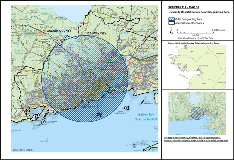
Map 38: University Hospital Galway Solar Safeguarding Zone | ||
The area known as University Hospital Galway Solar Safeguarding Zone is situated: | ||
(1) in the city of Galway being the area enclosed on map 38 (contained in Schedule 1) within the inner margin of the blue line and hatched in blue and is situated in whole or in part in the electoral division[s] of: Barna, Castlegar, Claddagh, Dangan, Eyre Square, Knocknacarragh, Lough Atalia, Menlough, Newcastle, Nuns Island, Rahoon, Renmore, Rockbarton, Salthill, Shantalla, St. Nicholas, Taylors Hill, and Wellpark, | ||
and | ||
(2) in the county of Galway being the area enclosed on map 38 (contained in Schedule 1) within the inner margin of the blue line and hatched in blue and is situated in whole or in part in the townland[s] of: Coolanillaun, Kentfield, and Tonabrocky. | ||
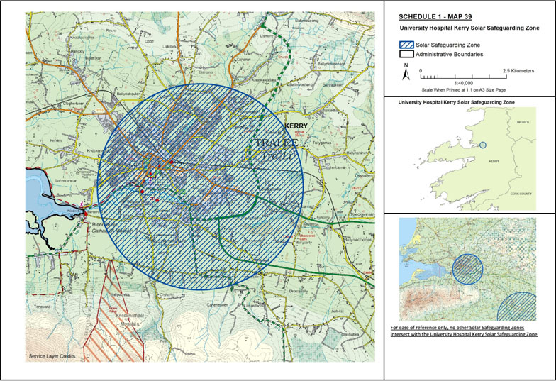
Map 39: University Hospital Kerry Solar Safeguarding Zone | ||
The area known as University Hospital Kerry Solar Safeguarding Zone is situated in the county of Kerry being the area enclosed on map 39 (contained in Schedule 1) within the inner margin of the blue line and hatched in blue and is situated in whole or in part in the townland[s] of: Ballingowan, Ballinorig East, Ballinorig South, Ballinorig West, Balloonagh, Ballyard, Ballybeggan, Ballydunlea, Ballymullen, Ballynahoulort, Ballyseedy, Ballyvelly, Buntalloon, Caherbreagh, Caherleheen, Cahermoneen, Caherslee, Caherweesheen, Camp, Carrigeendaniel, Clahane, Clash East, Clash West, Clashedmond, Cloghers, Cloon Beg, Cloon More, Cloonalour, Cloonanorig, Croogorts, Curraghleha East, Curraghleha West, Curragraigue, Dromthacker, Farranstephen, Gallowsfields, Garrane, Killeen, Killierisk, Knockanacuig, Knockawaddra Middle, Knockawaddra West, Kylebeg, Lisloose, Listellick South, Lohercannan, Manor East, Manor West, Monavally, Mounthawk, Muing East, Muing West, Pluckeen, Poulawaddra, Rahoonane, Ratass, Shanakill, Skahanagh, and Tralee. | ||
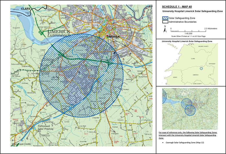
Map 40: University Hospital Limerick Solar Safeguarding Zone | ||
The area known as University Hospital Limerick Solar Safeguarding Zone is situated in the county of Limerick being the area enclosed on map 40 (contained in Schedule 1) within the inner margin of the blue line and hatched in blue and is situated in whole or in part in the townland[s] of: Ashfort, Ballinacurra (Bowman), Ballinacurra (Hart), Ballinacurra (Weston), Ballyclogh, Ballycummin, Ballykeeffe, Ballynoe, Ballysheedy East, Ballysheedy West, Baunacloka, Bunlicky, Caheranardrish, Castlemungret, Cloghkeating, Conigar, Corkanree, Courtbrack, Derrybeg, Derryknockane, Dooradoyle, Dromdarrig, Galvone, Gouldavoher, Kilrush, Lissanalta, Loughmore Common, Lurraga, Moneteen, Mountkennet, Prior’s-Land, Rathbane North, Rathbane South, Rathmale, Rathurd, Rootiagh, Rossbrien, Routagh, Roxborough, Skehacreggaun, and Sluggary. | ||
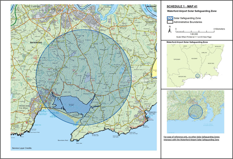
Map 41: Waterford Airport Solar Safeguarding Zone | ||
The area known as Waterford Airport Solar Safeguarding Zone is situated in the county of Waterford being the area enclosed on map 41 (contained in Schedule 1) within the inner margin of the blue line and hatched in blue and is situated in whole or in part in the townland[s] of: Ballinamona, Ballinattin, Ballinvella, Ballygarran, Ballygunnermore, Ballykinsella, Ballyknock, Ballyloughbeg, Ballynamoyntragh, Ballyshoneen, Callaghane, Carriglong, Castletown, Coolgower, Drumcannon, Duagh, Keiloge, Kilcaragh, Killowen, Killure, Kilmacleague East, Kilmacleague West, Knockhouse, Lisselan, Lisselan Intake, Monamintra, Orchardstown, Pickardstown, and Quillia. | ||
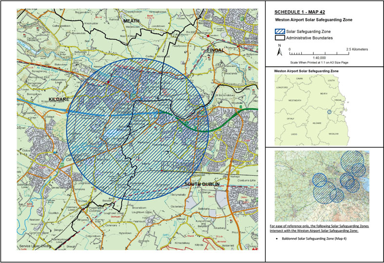
Map 42: Weston Airport Solar Safeguarding Zone | ||
The area known as Weston Airport Solar Safeguarding Zone is situated: | ||
(1) in the county of Kildare being the area enclosed on map 42 (contained in Schedule 1) within the inner margin of the blue line and hatched in blue and is situated in whole or in part in the townland[s] of: Allenswood, Backweston Park, Ballymadeer, Ballyoulster, Barnhall, Castletown, Commons, Coneyburrow, Confey, Donaghcumper, Easton, Elmhall, Kilmacredock Upper, Leixlip, Leixlip Demesne, Loughlinstown, Newtown, Parsonstown, Rinawade Lower, Rinawade Upper, St. Catherine’s, St. Catherine’s Park, St. Wolstans, Stacumny, and Stacumny Cottage, | ||
and | ||
(2) in the county of South Dublin being the area enclosed on map 42 (contained in Schedule 1) within the inner margin of the blue line and hatched in blue and is situated in whole or in part in the townland[s] of: Adamstown, Aderrig, Allenswood, Backstown, Backwestonpark, Ballymakaily, Coldblow, Cooldrinagh, Coolscuddan, Doddsborough, Esker South, Finnstown, Gollierstown, Laraghcon, Lucan and Pettycanon, Lucan Demesne, Mullauns, St. Catherine’s Park and Tobermaclugg. | ||
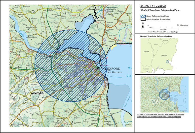
Map 43: Wexford Town Solar Safeguarding Zone | ||
The area known as Wexford Town Solar Safeguarding Zone is situated in the county of Wexford being the area enclosed on map 43 (contained in Schedule 1) within the inner margin of the blue line and hatched in blue and is situated in whole or in part in the townland[s] of: Ardcavan, Ballindinas, Ballyboggan, Ballygoman, Ballymacshoneen, Ballymorris, Ballynagee, Barntown, Burgess, Carricklawn, Clonard Great, Clonard Little, Colestown, College, Coolballow, Coolcots, Coolree, Cromwellsfort, Crosstown, Cullentra, Ferrybank North, Ferrybank South, Ferrycarrig, Hayestown Great, Killeen, Killeens, Killowen, Kitestown, Knockcumshin, Knottown, Larkinstown, Laurstown, Maudlintown, Moorfields, Mulgannon, Newbay, Newcastle, Newcastle Upper, Newtown, Park, Pembrokestown, Rocksborough, Saunderscourt, Shelmaliere Commons, Slipperygreen, Stonybatter, Tincone, Townparks, Whitemill North, Whitemill South, Whiterock North, Whiterock South, and Whitewell. | ||
| ||
GIVEN under my Official Seal, | ||
5 October 2022. | ||
DARRAGH O’BRIEN, | ||
Minister for Housing, Local Government and Heritage. | ||
EXPLANATORY NOTE | ||
(This note is not part of the instrument and does not purport to be a legal interpretation.) | ||
The geographical area of the Solar Safeguarding Zones classified by these Regulations are delineated and defined in Schedule 1 (a map or maps of the areas) and Schedule 2 (a list of the townlands in question / a description of the areas) of these Regulations. | ||
For more detailed maps than those contained in Schedule 1, or for greater detail on boundary delineation, please contact the Department of Housing, Local Government and Heritage or by viewing the relevant text or map details on www.myplan.ie |